
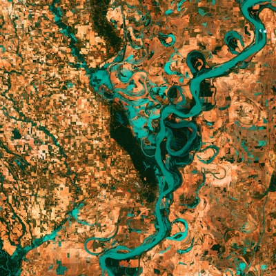
Artificial intelligence has evolved from a laboratory tool to a driver of change in sectors as diverse as healthcare, finance, and now geospatial analysis. A recent study has explored how large language models (LLMs) with multimodal capabilities, such as ChatGPT with vision, can classify satellite imagery to predict poverty levels at the village scale. This approach, combining natural language processing with computer vision, opens new possibilities for assessing human well-being in an interpretable, scalable, and cost-effective manner. Far from being a mere academic curiosity, this technology has profound implications for governments, NGOs, and companies seeking reliable data without relying on expensive and slow field surveys.
The method used in the research involves presenting pairs of satellite images to ChatGPT and asking it to rank them according to estimated poverty levels. The results show accuracy comparable to human experts, suggesting that LLMs can extract subtle visual patterns related to housing density, infrastructure, and land use. These findings are especially relevant in regions where traditional data, such as demographic and health surveys (DHS), are scarce or outdated. However, the study also warns about potential biases in anonymized public datasets, highlighting the need for a critical approach and robust validation tools.
From a business perspective, this multimodal analysis capability represents a unique opportunity. Organizations operating in emerging markets or managing development programs can integrate AI solutions to monitor socioeconomic changes in real time, optimize resource allocation, and improve decision-making. But achieving this requires more than just a language model; it demands a solid technological infrastructure covering everything from image collection and cloud storage to the deployment of secure and scalable AI models. This is where a company like Q2BSTUDIO delivers real value.
As specialists in custom software development, at Q2BSTUDIO we understand that each project requires a unique solution. For a satellite poverty classification system, we need not only to integrate a vision-enabled LLM API, but also to build a data pipeline that handles terabytes of images, processes them efficiently, and deploys results on interactive dashboards. Our expertise in AI allows us to train and fine-tune specific models, whether using ChatGPT, open-source models, or developing hybrid architectures that combine traditional computer vision with LLMs. Furthermore, we ensure that all solutions are deployed with the highest standards of cybersecurity, protecting sensitive data both in transit and at rest.
Scalability is another critical factor. Processing satellite imagery of entire regions requires robust cloud infrastructure. We work with cloud AWS and Azure to design serverless architectures that automatically adapt to demand, optimizing cost and performance. Services like AWS SageMaker or Azure Machine Learning allow distributed training of AI models, while geospatial databases such as Amazon RDS or Azure Cosmos DB manage the information. Additionally, we integrate Business Intelligence (BI) with Power BI to transform predictions into interactive dashboards that policy makers or executives can explore without technical knowledge. An AI-generated poverty map, filtered by region and updated weekly, becomes an invaluable planning tool.
Another emerging field is AI agents, which can automate the entire workflow: from scheduled downloads of satellite images (e.g., from Sentinel or Landsat) to running inferences and generating reports. At Q2BSTUDIO we develop intelligent agents that integrate with ERP, CRM, and data platforms so that satellite poverty information feeds directly into business or governmental decision-making processes. For instance, an agent could detect a deterioration in a village's conditions and trigger an alert to a humanitarian aid program, all within hours.
The combination of multimodal LLMs, geospatial analysis, and automation not only reduces costs but also democratizes access to high-quality data. Small NGOs or startups can now access capabilities previously reserved for large space agencies, thanks to affordable AI APIs and the power of the cloud. However, successful implementation requires deep knowledge of both the technology and the domain. At Q2BSTUDIO we offer end-to-end consulting and development, from proof of concept to production deployment, ensuring each solution meets accuracy, privacy, and scalability requirements.
Finally, it is important to reflect on limitations. The study mentions that public datasets like DHS may not be fully reliable for retrieving wealth indices, introducing biases into models. Therefore, we recommend combining multiple data sources (images, surveys, mobile data) and applying fairness techniques in AI. At Q2BSTUDIO we incorporate bias audits and explainability in our developments, ensuring AI solutions are transparent and ethical. Multimodal vision of ChatGPT is a powerful tool, but only with solid software engineering and a strategic business approach can these advances be transformed into real impact. If your organization is exploring the use of AI for geospatial analysis or any other field, do not hesitate to contact us. At Q2BSTUDIO we turn ideas into software that makes a difference.